
News
Results of Taiwan’s GIS Assistance Garner International Attention
Support in operating geographic information systems (GIS), provided by the TaiwanICDF to authorities in Honduras monitoring mangrove habitats on their country’s southern coast, has recently garnered attention from the United Nations Environment Programme (UNEP) and been cited in international journals.
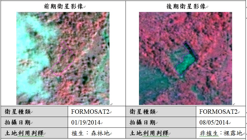
The TaiwanICDF project, Capability Enhancement in Using Geographic Information Systems in Central America, utilizes Taiwan’s Formosat-2 satellite to provide real-time satellite images and change analysis data, assisting Central American partner countries to control land use and change effectively, as well as to respond more rapidly and effectively in the aftermath of natural disasters, reducing the impact and losses caused by such events.
One of the project’s regular monitoring components has focused on assisting Honduran authorities to monitoring mangrove systems along the country’s southern coast, utilizing satellite images gathered between 1985 and 2013 to analyze growth and decline in the distribution of the habitat so that the government could formulate policies designed to protect changes to national land.
As part of the evolution of the project the initiative’s implementing agency, the Center for Space and Remote Sensing Research at Taiwan’s National Central University, has also carried out a number of research activities. Associated findings were published in the journal Remote Sensing in November 2013 and cited by the UNEP’s World Conservation Monitoring Centre (WCMC), as well as published in a 2014 UNEP-WCMC international report, The Importance of Mangroves to People: A Call to Action, demonstrating that the results of the project have garnered a high degree of attention from international journals and organizations.
Related Pictures
- Update: 2018/03/01
- Hits:686